(Sredinny Range)
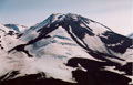 Fig. 2
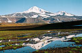 Fig. 3
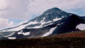
Fig. 4
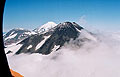
Fig. 5
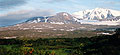
Fig. 6
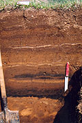
Fig. 7
No
eruptions from the Sredinny Range
volcanoes have been mentioned in the historical records (last
200-300 years).
This is likely the reason for a widely accepted opinion
that Sredinny Range volcanism either is dying or is already dead. In
addition, existence of recent volcanism north of the presumed northern
boundary of the subducting Pacific plate, beyond an active subduction
zone, does not fit into dominating tectonic models (e.g. Park et
al., 2002). The first catalogue of the
Sredinny Range volcanoes (Ogorodov et
al.,1972), however, described many Holocene
volcanoes extending as far as 58.37°N. These preliminary age
estimates were based mainly on "freshness" of
the volcanic topography. Recent studies based on
tephrochronology and 14C dating (Pevzner, 2006) have
allowed to identify and document the following volcanic centers, which
are likely the northernmost of the Holocene volcanoes in Kamchatka.
The northernmost of the Kamchatka Holocene
volcanoes known so far is a monogenic cinder cone Tobeltsen (58°15′N, 160°44′E,
elev. 831.8 m) and an associated lava flow descending to the Voyampolka
River valley (Fig. 1).
Erupted products are medium-K basalt. Based on tephrochronology and
radiocarbon dating,
Tobeltsen cone formed ~3.5 ka BP (Fig. 7).
Next Holocene volcano, located 11 km SSE of
Tobeltsen, is a small, previously nameless cinder cone
called X Cone by Maria Pevzner (2006) (Figs. 2 and 3;
58°10′N, 160°48′E; elev. 2127.5 m). X Cone sits in the
axial part of the Sredinny Range and is
composed of medium-K basalt. Based on tephrochronology and radiocarbon
dating, the cone formed about 4.0 ka BP
(Fig. 7).
Spokoiny volcano (Figs.4
and 5; 58°08′ N, 160°49′E; elev. 2170.6 m; GVP
number 1000-671) is located on the divide of the Levaia
Nachika and Kutina rivers. It was called Kutina volcano by Ogorodov
et al. (1972), but modern maps call it Spokoiny that means "quiet" in
Russian. The volcano was active repeatedly in the early and middle
Holocene; the most recent of its five explosive eruptions, identified so
far, took place ~5.4 ka BP. Erupted products are
medium to
high-K dacite-rhyolite.
Nylgimelkin (Fig.
6; 57°58′ N, 160°39′E,
elev. 1621.0 m; GVP number 1000-65) is a small shield-like volcano
crowned by
a couple of cinder cones. Based on the tephrochronology and radiocarbon
dating, it formed ~5.5 ka BP. The volcano was mentioned as Atlasov
volcano by Ogorodov et al. (1972). Erupted products are medium-K basalt.
Cinders of Tobeltsen, X
Cone and Nylgimelkin form distinct layers in the
soil-pyroclastic sequence and can all be seen together in a number of
sections (Fig. 7).
Literature
Ogorodov N. V., Kozhemyaka
N. N., Vazheevskaya A. A., and A. Ogorodova (1972)
Volcanoes and Quaternary Volcanism in the Sredinnyi Ridge of
Kamchatka. Nauka, Moscow [in Russian]
Pevzner
M.M. (2006) Holocene volcanism of Northern Kamchatka: The spatiotemporal
aspect. Doklady of the Russian Academy of Sciences, Earth Sciences,
Vol.
409A, No. 6, pp. 884–887. Original Russian text published in Doklady
Akademii Nauk, 2006, Vol. 409, No. 5, pp. 648–651.
Siebert
L, and Simkin T (2002-).
Volcanoes of the
World: an Illustrated Catalog of Holocene Volcanoes and their Eruptions .
Smithsonian Institution, Global Volcanism Program, Digital Information
Series, GVP-3, (http://www.volcano.si.edu/world/).