1000-03
51°30' N, 157°12' E, summit elevation 1578 m
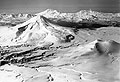
Fig.1
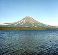
Fig.2
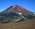
Fig.3
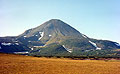
Fig.4
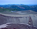
Fig.5
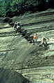
Fig.6
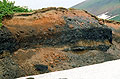
Fig.7
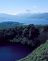
Fig.8
Iliinsky volcano is located at the northeastern shore of the
Kurile Lake (Figs. 1 and 2). The volcano sits in a depression, which
may be the collapse crater of an earlier volcano. The collapse likely
occurred due to the earthquakes accompanying the catastrophic Kurile
Lake caldera eruption ab. 7600 14C yr BP (Ponomareva
et al., 2004; Zaretskaia et al., 2001).
Pyroclastic deposits from Illinsky directly overlie the Kurile Lake caldera ignimbrite, so the volcano started to form soon after the caldera-forming eruption. The similarity of the K2O versus SiO2 trends of the Iliinsky rocks and the Kurile Lake caldera pyroclastic deposits, suggests a genetic relationship. Initial eruptions of Illinsky between 7600 and ~6500 14C yrs BP produced basaltic andesite to dacite lava flows and tephra. Following a 1700 year repose period, Iliinsky produced a large explosive eruption ~4850 14C yrs BP (Ponomareva et al., 2001). The volcanic cone reached its modern shape and height about 1900 14C yrs BP, and then entered a 2000-yrs-long repose period. The eruptions, preceding the repose, produced sequence of tephra layers and thick andesitic lava flows (Figs. 3 - 7).
In 1901, a phreatic eruption formed a large crater on the eastern slope of the volcano (Figs. 1 and 5), and may herald the start of a new period of activity (Ponomareva et al., 2001).
The largest eruptions from Iliinsky produced up to 1 km3 of tephra which was spread >50 km from the volcano.
Composition of the Iliinsky erupted products ranges from basalts to dacites. Silicic and mafic tephra varieties may occur in the same layer and could have been produced during a single eruption (Fig. 7).
While eastern slope of the volcano hosts only one large flank crater (Figs.1 and 5), western slope is dotted with many flank vents. A large maar is located at a distance of 6 km from the volcano's summit (Fig. 8).
Important marker tephra layers helpful for deciphering the complicated Iliinsky stratigraphy are: KSht1 (~950 14C yr BP) from Ksudach volcano, DG II (4400 14C yr BP) and DG III (1600 14C yr BP) from Dikii Greben' volcano, KHD (~2500 14C yr BP) from Khodutkinsky Crater. These ashes differ from the Iliinsky tephras in composition and grain size. Some pumice layers from Iliinsky, e.g. layer ZLT (also known as "upper coconuts", ~4850 14C yr BP), also serve as good local markers.
Vera Ponomareva
Literature
Bondarenko VI (1991) Seismic reflection profiling in Lake Kurilskoe. Volcanology and Seismology 12/4: 533-548
Masurenkov YuP, Ed. (1980) Long existing center of endogenic activity in South Kamchatka. Nauka, Moscow, 300 pp. (in Russian)
Novograblenov PT (1932) The catalogue of volcanoes of Kamchatka. Isvestiya Gos. Geogr. Sci. XIY-l:88-99 (In Russian)
Ponomareva VV, Sulerzhitsky LD, Dirksen OV, Zaretskaia NE. 2001. Holocene paleosols as records of intervals of volcanic quiescence in the Kurile Lake region, South Kamchatka. In: E. Juvigné & J.P. Raynal (eds.) "TEPHRAS, chronology, archaeology". Les dossiers de l'Archéo-Logie n° 1. CDERAD ed., pp. 91-100
Ponomareva VV., Kyle P.R., Melekestsev I.V., Rinkleff P.G., Dirksen O.V., Sulerzhitsky L.D., Zaretskaia N.E., Rourke R. (2004) The 7600 (14C) year BP Kurile Lake caldera-forming eruption, Kamchatka, Russia: stratigraphy and field relationships. J Volcanol Geotherm Res 136: 199–222
Zaretskaia NE, Ponomareva VV, Sulerzhitsky LD, Dirksen OV (2001) Radiocarbon dating of the Kurile Lake caldera eruption (South Kamchatka, Russia) Geochronometria, 20: 95-102