1000-21
Young Gamchen: 54°58' N, 160°43' E, summit elevation 2577 m
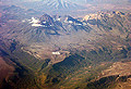
Fig.1
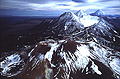
Fig.2
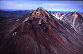
Fig.3
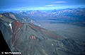
Fig.4
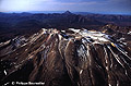
Fig.5
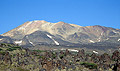
Fig.6
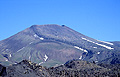
Fig.7
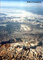
Fig.8
Gamchen volcanic group is a traditional name for a volcanic range of the overall N-S orientation, which comprises at least three Holocene volcanoes and several more Late Pleistocene ones (Figs.1 and 2). This range forms the northern terminus of the Eastern volcanic belt - Kamchatka's volcanic front related to the subduction of the Pacific plate.
Gamchen range comprises the following volcanoes (from south to north): Gamchen massif with a Holocene Baranii ("Sheep's") cone (Figs.3,4), Komarov, named after famous Russian botanist Vladimir Komarov (Figs.5,6), and Vysokii ("High"; Figs.7,8).
Gamchen massif consists of three Late Pleistocene and one Holocene cones (Figs.3,4). Holocene cone named Baranii started to form at the slope of its predecessor about 3600 14C years BP as evidenced by stratigraphic position of its cinders immediately below AV1 marker ash (3500 14C years BP) from Avachinsky volcano. The cone has been formed in several spurts of activity within an interval of 3600-3000 14C years BP. Cinders and ash of these eruptions can be traced at a distance of at least 100 km from the volcano. Lukovitsa ("Onion clove"; Fig.4) extrusive dome formed at the final stages of the Baranii cone formation. Both are composed of low-potassic basalt-basaltic andesite. Baranii cone cinders are dense bombs and lapilli rich in plagioclase crystals and allivalite inclusions, and are very similar in appearance to other low-potassic basalt-basaltic andesite cinders from frontal zone volcanoes such as Kikhpinych, Zheltovsky and Kambalny. In Early Holocene Gamchen experienced several sector collapses. Debris avalanche deposits form a field of hummocky topography ("Moon hills") on the eastern slope of the volcano. Most of them were earlier mapped as lava flows (Fedotov and Masurenkov, 1991). Huge conic toreva blocks at the foot of the volcano mimic individual volcanic cones. Later debris flows were associated with Baranii cone formation.
Komarov, Vysokii and at least one nameless cone between them (Fig.8) form a volcanic ridge very likely associated with the single magmatic system. The rocks of the two volcanoes are medium-potassic tholeitic andesites-basaltic andesites, which are similar in composition and definitely differ from those of Gamchen volcano. The northern edifice, Vysokii ("High") volcano, appeared to be the most active and produced numerous explosive and effusive eruptions. Curious is that namely this, most active vent has never been included into any catalogue (e.g. Vlodavets, 1957; Fedotov and Masurenkov, 1991; Simkin and Siebert, 1994). Our recent field investigations show that Vysokii has been active since the beginning of Holocene till about 2000 14C years BP, while Komarov likely started to form about 1500 14C years BP, after Vysokii had terminated its activity. Komarov volcano has many active fumaroles. Both volcanoes erupted porous black cinders and ash (of both andesitic and basaltic andesite composition), yellowish and beige andesitic pumice and lava flows up to 10 km long. Lava flows gave birth to extensive lahars.
Good markers for the Holocene stratigraphy of this region are the following marker ashes: SH2 (1000 yr BP) and SH3 (1400 yr BP) from Shiveluch volcano, OP (1500 yr BP) from Baranii Amphitheater crater, KS1 (1800 yr BP) from Ksudach volcano, AV1 (3500 yr BP) and AV4 (5500 yr BP) from Avachinsky volcano, KHG (7000 yr BP) from Khangar, and KZ (7600 yr BP) from Kizimen (all ages are radiocarbon ones).
Literature
Churikova TG, Dorendorf F, Wörner G. (2001) Sources and fluids in the mantle wedge below Kamchatka, evidence from across-arc geochemical variation. Journal of Petrology, 42/8: 1567-1593