1000-45
Alney volcano
56°41′N, 159°38′E; elevation 2598.0 m
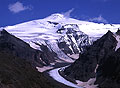
Fig. 1
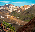
Fig. 2
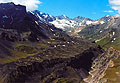
Fig. 3
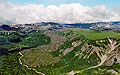
Fig. 4
Alney volcano (Fig. 1) is the main summit of the
Alney–Chashakondzha volcanic massif, located ~100 km west of Shiveluch
volcano, on the Kirevna,
Belaia, and Kalgauch rivers divide.
Most of the massif dates back to the
mid-Pleistocene time. It
is
strongly eroded
and heavily glaciated (Figs 1 and 2). Alney crowns a younger,
northern part of the massif.
Two flank eruptions as well as a few tephra
layers at the foot of Alney evidence recent volcanic
activity in the Alney-Chashakondzha massif.
A number of tephra layers have been found at
the volcano's foot. Some of those likely originated from Alney or from some smaller center(s) in its area, now covered with snow
(Pevzner, 2004). The largest explosive eruption occurred 4.0-4.1 14C
ka BP and produced fine ash with an admixture of rock fragments
(Pevzner, 2006). The most recent eruption likely occurred only ~350 yrs
ago. Lavas sampled close to the Alney summit
are medium-K andesite.
Two well-expressed Holocene cinder cones and
related lava flows are located at the eastern and south-eastern slopes
of the Alney–Chashakondzha massif: these are Levaia Belaia River flow (source at 56°38′N, 159°43′E, 1200 m) and Kireunsky lava flow (source at 56°41′N,
159°44′E, 1300 m). Based on the tephrochronological data, both were
formed ~2.6 ka 14C yrs BP, one after the other: first Levaia
Belaia River flow, and then - Kireunsky flow.
Levaia Belaia River cone is located ~8
km SE of the Alney summit. Related 3.5 km long lava flow descended a steep slope and filled
the river valley (Fig. 3). Tephra of this eruption is coarse
non-porous cinder, which was traced downwind at a distance of >16 km.
Products of this eruption are medium-K
basaltic andesite - andesite with a volume of 0.2-0.25 km3.
Kireunsky cinder cone is
located 5.5 km east of Alney. Related lava flow is 9 km
long (Fig. 4). Tephra of this eruption is coarse
non-porous cinder, which was traced downwind at a distance of >11 km.
Kireunsky products are medium-K
andesite with a volume of ~0.2 km3.
Literature
Ogorodov N. V., Kozhemyaka N. N., Vazheevskaya A. A., and A. Ogorodova
(1972)
Volcanoes and Quaternary Volcanism in the Sredinnyi Ridge of Kamchatka. Nauka, Moscow [in Russian]
Pevzner M.M. (2004) New data on Holocene monogenetic volcanism of the
Northern Kamchatka: ages and space distribution. Linkages among Tectonics,
Seismicity, Magma Genesis, and Eruption in Volcanic arcs: IV
International Biennial Workshop on Subduction Processes emphasizing the Japan-Kurile-Kamchatka-Aleutian Arcs. Petropavlovsk-Kamchatsky, August 21-27, 2004, pp. 72-76.
http://www.kscnet.ru/ivs/conferences/kasp/tez/contents.htm
Pevzner
M.M. (2006) Holocene volcanism of Northern Kamchatka: The spatiotemporal
aspect. Doklady of the Russian Academy of Sciences, Earth Sciences, Vol.
409A, No. 6, pp. 884–887. Original Russian text published in Doklady
Akademii Nauk, 2006, Vol. 409, No. 5, pp. 648–651.
Siebert
L, and Simkin T (2002-). Volcanoes of the
World: an Illustrated Catalog of Holocene Volcanoes and their Eruptions.
Smithsonian Institution, Global Volcanism Program, Digital Information
Series, GVP-3, (http://www.volcano.si.edu/world/).