1984-1991 – инженер – мнс, Институт вулканологии ДВО РАН
1991-2004 – мнс - снс, Институт вулканической геологии и геохимии ДВО
РАН
2004-настоящее время – снс - внс, Институт вулканологии и сейсмологии
ДВО РАН
1984-1999
– научный сотрудник Научного Музея вулканологии ИВ и ИВГиГ ДВО
РАН
2002-2014 – доцент кафедры географии, геологии и геофизики
КамГУ им. В. Беринга
Курсы: «Основы вулканологии»
«Петрофизика»
Образование
1984 – геолог, Геологический факультет МГУ им. М.В. Ломоносова, Россия
1994 – к.г.-м.н. – Геологический факультет МГУ им. М.В. Ломоносова, Россия
Тема: Современные пирокластические отложения вулканов Камчатки и их
инженерно-геологические особенности. Руководитель: профессор
МГУ им. М.В. Ломоносова д.г.-м.н. В.Т. Трофимов
02.1999-06.2000 – Постдок, Государственный университет в г. Баффало, Нью-Йорк,
США
Тема: Динамическая модель палящих туч вулкана Безымянный, Камчатка. Руководитель:
Профессор Маркус И. Бурсик
- Вулканический пепел и безопасность для авиации
- Пирокластические отложения современных извержений андезитовых вулканов
- Моделирование движения пирокластических потоков
- Лавовые образования андезитовых вулканов
Girina O.A., Loupian E.A., Ozerov A.Yu., Melnikov D.V., Manevich A.G., Petrova E.G. The Activity of Kamchatka Volcanoes and theirs Danger to Human Society (oral report) // JpGU - AGU Joint Meeting 2021: Virtual. 30 May - 06 July, 2021, Japan, Tokyo. 2021. № C001019.
Аннотация
There are 30 active volcanoes in the Kamchatka, and several of them are continuously active. In the XX-XXI centuries 17 volcanoes of Kamchatka erupted. During this time, 183 volcanic eruptions occurred, including three catastrophic eruptions (Ksudach, 1907; Bezymianny, 1956; Sheveluch, 1964). Strong explosive eruptions of volcanoes were the most dangerous for human society because they produce in a few hours or days to the atmosphere till 2-3 cubic kilometers of volcanic products. Ash plumes and the clouds, depending on the power of the eruptions, the strength and wind speed, to traveled thousands of kilometers from the volcanoes for several days. Any territory of the Kamchatka Peninsula has repeatedly been exposed to ash falls, the thickness of ash in settlements was from less than 1 mm to 4-5 cm. Strong explosive eruptions of volcanoes Sheveluch, Klyuchevskoy, Bezymianny, Kizimen, Karymsky, Zhupanovsky, Avachinsky, Kambalny were the most dangerous for air travel not only over Kamchatka, but also hundreds of kilometers away from the peninsula.
The strong explosive and effusive eruptions of Sheveluch, Klyuchevskoy, Bezymianny, Kizimen and the other were often accompanied by the formation of hot mud flows (lahars), which sometimes disrupted transport communications (roads, bridges) of nearby settlements.
Scientists of KVERT monitor Kamchatkan volcanoes since 1993. Thanks to satellite monitoring of volcanoes carried out by KVERT, several explosive eruptions were predicted in the XXI century, and early warnings were made to the population about possible ashfalls in settlements and about hazard to aviation.
Girina O.A., Loupian E.A., Sorokin A.A., Romanova I.M., Melnikov D.V., Manevich A.G., Nuzhdaev A.A., Bartalev S.A., Kashnitskii A.V., Uvarov I.A., Korolev S.P., Malkovsky S.I., Kramareva L.S. Information Technologies for the Analyzing of Kamchatka and the Kuril Islands Volcanoes Activity in 2019-2020 // Short Paper Proceedings of the VI International Conference on Information Technologies and High-Performance Computing (ITHPC 2021), Khabarovsk, Russia, September 14-16, 2021. Khabarovsk: CEUR-WS.org. 2021. V. 2930. P. 112-118.
Аннотация
The work is devoted to the activity analysis of Kamchatka and the Kuril Islands volcanoes in 2019-2020.The activity of the volcanoes was estimated based on the processing of data from daily satellite monitoring carried out using the information system “Remote monitoring of Kamchatkan and the Kuriles volcanoes activity (VolSatView)”. The activity of the Kamchatka and the Kuril Islands volcanoes considered based on the analysis of their thermal anomalies. Analysis of the characteristics of thermal anomalies over volcanoes was carried out in KVERT IS. Analysis of the temperature of thermal anomalies of volcanoes in the Kuril - Kamchatka region in 2019-2020 shows a significantly higher activity of the Kamchatka volcanoes in comparison with the Kuril volcanoes.
Horváth Á, Carr J.L., Girina O.A., Wu D.L., Bril A.A., Mazurov A.A., Melnikov D.V., Hoshyaripour G.A., Buehler S.A. Geometric estimation of volcanic eruption column height from GOES-R near-limb imagery – Part 1: Methodology // Atmospheric Chemistry and Physics. 2021. V. 21. V. 16. P. 12189-12206. https://doi.org/10.5194/acp-21-12189-2021, 2021 Аннотация
A geometric technique is introduced to estimate the height of volcanic eruption columns using the generally discarded near-limb portion of geostationary imagery. Such oblique observations facilitate a height-by-angle estimation method by offering close-to-orthogonal side views of eruption columns protruding from the Earth ellipsoid. Coverage is restricted to daytime point estimates in the immediate vicinity of the vent, which nevertheless can provide complementary constraints on source conditions for the modeling of near-field plume evolution. The technique is best suited to strong eruption columns with minimal tilting in the radial direction. For weak eruptions with severely bent plumes or eruptions with expanded umbrella clouds the radial tilt/expansion has to be corrected for either visually or using ancillary wind profiles. Validation on a large set of mountain peaks indicates a typical height uncertainty of ±500 m for near-vertical eruption columns, which compares favorably with the accuracy of the common temperature method.
Horváth Á, Girina O.A., Carr J.L., Wu D.L., Bril A.A., Mazurov A.A., Melnikov D.V., Hoshyaripour G.A., Buehler S.A. Geometric estimation of volcanic eruption column height from GOES-R near-limb imagery – Part 2: Case studies // Atmospheric Chemistry and Physics. 2021. V. 21. V. 16. P. 12207-12226. https://doi.org/10.5194/acp-21-12207-2021 Аннотация
In a companion paper (Horváth et al., 2021), we introduced a new technique to estimate volcanic eruption column height from extremely oblique near-limb geostationary views. The current paper demonstrates and validates the technique in a number of recent eruptions, ranging from ones with weak columnar plumes to subplinian events with massive umbrella clouds and overshooting tops that penetrate the stratosphere. Due to its purely geometric nature, the new method is shown to be unaffected by the limitations of the traditional brightness temperature method, such as height underestimation in subpixel and semitransparent plumes, ambiguous solutions near the tropopause temperature inversion, or the lack of solutions in undercooled plumes. The side view height estimates were in good agreement with plume heights derived from ground-based video and satellite stereo observations, suggesting they can be a useful complement to established techniques.
Korolev S.P., Sorokin A.A., Urmanov I.P., Kamaev A., Girina O.A. Classification of Video Observation Data for Volcanic Activity Monitoring Using Computer Vision and Modern Neural NetWorks (on Klyuchevskoy Volcano Example) // Remote Sensing. 2021. V. 13. V. 23. № 4747. P. 1-20. https://doi.org/10.3390/rs13234747 Аннотация
Currently, video observation systems are actively used for volcano activity monitoring. Video cameras allow us to remotely assess the state of a dangerous natural object and to detect thermal anomalies if technical capabilities are available. However, continuous use of visible band cameras instead of special tools (for example, thermal cameras), produces large number of images, that require the application of special algorithms both for preliminary filtering out the images with area of interest hidden due to weather or illumination conditions, and for volcano activity detection. Existing algorithms use preselected regions of interest in the frame for analysis. This region could be changed occasionally to observe events in a specific area of the volcano. It is a problem to set it in advance and keep it up to date, especially for an observation network with multiple cameras. The accumulated perennial archives of images with documented eruptions allow us to use modern deep learning technologies for whole frame analysis to solve the specified task. The article presents the development of algorithms to classify volcano images produced by video observation systems. The focus is on developing the algorithms to create a labelled dataset from an unstructured archive using existing and authors proposed techniques. The developed solution was tested using the archive of the video observation system for the volcanoes of Kamchatka, in particular the observation data for the Klyuchevskoy volcano. The tests show the high efficiency of the use of convolutional neural networks in volcano image classification, and the accuracy of classification achieved 91%. The resulting dataset consisting of 15,000 images and labelled in three classes of scenes is the first dataset of this kind of Kamchatka volcanoes. It can be used to develop systems for monitoring other stratovolcanoes that occupy most of the video frame.
Гирина О.А., Лупян Е.А., Маневич А.Г., Мельников Д.В., Сорокин А.А., Крамарева Л.С., Романова И.М., Нуждаев А.А., Кашницкий А.В., Марченков В.В., Уваров И.А., Мальковский С.И., Королев С.П. Дистанционные наблюдения эксплозивно-эффузивного извержения вулкана Ключевской в 2019-2020 гг. // Современные проблемы дистанционного зондирования Земли из космоса. 2021. Т. 18. № 1. С. 81-91. https://doi.org/10.21046/2070-7401-2021-18-1-81-91 Аннотация
Вулкан Ключевской — один из наиболее активных вулканов мира. В 2019–2020 гг. эксплозивно-эффузивное извержение вулкана продолжалось 8 мес. Эксплозивное извержение проявлялось в стромболианской активности и реже — в вулканской. Эксплозии поднимали пепел до 7 км над уровнем моря, пепловые шлейфы перемещались до 500 км в различных направлениях от вулкана. Основная площадь территории, на которой отмечались пеплопады, составляла более 60 тыс. км2. Эффузивная фаза извержения началась 18 апреля 2020 г. и продолжалась почти 2,5 месяца вплоть до окончания извержения. 18–30 апреля была отмечена наиболее высокая температура термальной аномалии в районе вулкана и наиболее плотные пепловые шлейфы, в которые помимо свежего пепла примешивался материал обвалов с бортов Апахончичского жёлоба. Протяжённость лавового потока составила 1,5 км; грязевые отложения покрыли территорию на площади около 1,7 км2. В работе дано описание хода извержения и предваряющих его событий на основании изучения видеоматериалов и различных спутниковых данных в информационной системе «Дистанционный мониторинг активности вулканов Камчатки и Курил» (VolSatView, http://kamchatka.volcanoes.smislab.ru).
Гирина О.А., Маневич А.Г., Мельников Д.В., Нуждаев А.А., Кашницкий А.В., Уваров И.А., Романова И.М., Сорокин А.А., Мальковский С.И., Королев С.П., Крамарева Л.С. Спутниковый мониторинг эксплозивного извержения вулкана Чиринкотан (Северные Курилы) в 2021 г. // Современные проблемы дистанционного зондирования Земли из космоса. 2021. Т. 18. № 5. С. 321-327. https://doi.org/10.21046/2070-7401-2021-18-5-321-327 Аннотация
Остров-вулкан Чиринкотан находится в тыловой зоне Северных Курильских островов. Эруптивная деятельность вулкана представлена эксплозивными (вулканского типа) и эксплозивно-эффузивными извержениями умеренной силы; состав пород — андезиты. Имеются сведения о восьми исторических извержениях вулкана. В работе дано описание хода извержения в августе 2021 г. на основании изучения различных спутниковых данных в информационной системе «Дистанционный мониторинг активности вулканов Камчатки и Курил» (VolSatView, http://kamchatka.volcanoes.smislab.ru). На влк. Чиринкотан 8–10, 15, 17, 18, 22 и 23 августа отмечались единичные эксплозии, 14 августа — три эксплозивных события. Пепловые облака перемещались в основном на запад, юго-запад, восток и юго-восток от вулкана. Общая площадь пеплопадов в течение извержения превышала 55 тыс. км2. Неоднократно пепел влк. Чиринкотан выпадал на островах Райкоке, Матуа, Расшуа, Экарма, Шиашкотан, Харимкотан и Онекотан. Показатель вулканической активности (Volcanic Explosivity Index) этого извержения оценивается как 2. Активность вулкана в августе была опасной для местных авиаперевозок.
Chirinkotan volcano–island is located in the rear zone of the Northern Kuril Islands. The eruptive activity of the volcano is represented by explosive (Vulcanian type) and explosive-effusive eruptions of moderate intensity; the composition of the rocks is andesite. There is information about eight historical volcanic eruptions. The paper describes the course of the eruption in August 2021 based on the study of various satellite data in the information system “Remote monitoring of Kamchatka and Kuril Islands volcanic activity” (VolSatView, http://kamchatka.volcanoes.smislab.ru). Single explosions on Chirinkotan volcano were noted on August 8–10, 15, 17, 18, 22 and 23; and three explosive events took place on August 14. Ash clouds moved mainly west, southwest, east and southeast of the volcano. The total area of ash falls during the eruption exceeded 55 thousand km2. Chirinkotan volcano ash repeatedly fell on the Islands of Raikoke, Matua, Rasshua, Ekarma, Shiashkotan, Harimkotan and Onekotan. For this eruption, the Volcanic Explosivity Index is rated 2. The activity of the volcano in August was hazardous to local aviation
Гирина О.А., Маневич А.Г., Мельников Д.В., Нуждаев А.А., Романова И.М., Лупян Е.А., Сорокин А.А., Крамарева Л.С. Активность вулканов Камчатки и Курильских островов в 2020-2021 гг. и их опасность для авиации // Вулканизм и связанные с ним процессы. Материалы XXIV ежегодной научной конференции, посвящённой Дню вулканолога, 29-30 марта 2021 г. Петропавловск-Камчатский: ИВиС ДВО РАН. 2021. С. 25-28.
Гирина О.А., Мельников Д.В., Лупян Е.А., Маневич А.Г., Сорокин А.А., Крамарева Л.С. Непрерывный мультиспутниковый мониторинг вулканов для обнаружения извержений на примере бокового прорыва вулкана Ключевской в феврале 2021 г. // Современные проблемы дистанционного зондирования Земли из космоса. 2021. Т. 18. № 1. С. 261-267. https://doi.org/10.21046/2070-7401-2021-18-1-261-267 Аннотация
Вулкан Ключевской — один из наиболее активных вулканов мира. В 2019–2021 гг. произошло два вершинных эксплозивно-эффузивных извержений вулкана с перерывом в 88 дней. 17 февраля 2021 г., спустя 9 дней после окончания вершинного извержения, на высоте 2,8 км н. у. м. на северо-западном склоне вулкана появился боковой прорыв. Его обнаружение произошло благодаря непрерывному мониторингу вулкана с помощью спутниковых данных низкого, среднего и высокого разрешения, доступных в информационной системе «Дистанционный мониторинг активности вулканов Камчатки и Курил» (VolSatView, http://kamchatka.volcanoes.smislab.ru). Термальная аномалия в районе прорыва была обнаружена по спутниковым снимкам среднего разрешения, подтверждение извержения выполнено по снимкам высокого разрешения, динамика развития прорыва — по снимкам низкого разрешения (Himawari-8). В районе прорыва образовались две трещины, из которых вытекали лавовые потоки. К 21–22 февраля лавовые потоки начали внедряться в ледник Эрмана. Грязевые потоки от фронтов лавовых потоков по р. Крутенькой прошли в 7 км от пос. Ключи в направлении к р. Камчатке. К 28 февраля нижняя трещина прекратила работу, но извержение бокового прорыва активно продолжается: растёт шлаковый конус, увеличивается площадь лавового поля. Прорыв 2021 г. назван именем чл.-корр. АН СССР Г. С. Горшкова.
Гирина О.А., Мельников Д.В., Маневич А.Г., Нуждаев А.А., Романова И.М., Лупян Е.А., Кашницкий А.В., Сорокин А.А., Крамарева Л.С. Эксплозивное извержение вулкана Безымянный 21 октября 2020 г. // Вулканизм и связанные с ним процессы. Материалы XXIV ежегодной научной конференции, посвящённой Дню вулканолога, 29-30 марта 2021 г. Петропавловск-Камчатский: ИВиС ДВО РАН. 2021. С. 29-31.
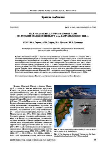
Гирина О.А., Озеров А.Ю., Цветков В.А., Демянчук Ю.В. Выжимание пластичных блоков лавы на вулкане Молодой Шивелуч (п-ов Камчатка) в 2020–2021 гг. // Вестник КРАУНЦ. Серия: Науки о Земле. 2021. Вып. 51. № 3. С. 77-83. https://doi.org/10.31431/1816-5524-2022-3-51-77-83 Аннотация
Вулкан Молодой Шивелуч — один из самых активных вулканов Камчатки. С августа 1980 г. по настоящее время в кратере вулкана происходит рост экструзивного купола. Пластичные лавы в виде крупных лент отмечались на куполе уже в 1980–1981 гг., первый лавовый поток наблюдался после пароксизмального извержения 9 мая 2004 г. Очередной крупный блок лавы начал выжиматься с конца апреля — начала мая 2020 г., к 11 июня он поднимался над куполом на 50–80 м, к концу октября — до 120 м. 28 сентября было отмечено, что блок лавы приобрел гладкие поверхности. Порции лавы, выдавленные из недр вулкана в августе–сентябре, были пластичными. К 8 декабря блок разрушился. В феврале 2021 г. из разрушенного блока начал подниматься новый блок пластичной лавы, в марте его высота над куполом превысила 50–60 м, в июне — 200 м.
Volcano Young Sheveluch is one of the most active volcanoes in Kamchatka. Since August 1980 to the present time, an extrusive dome has been growing in the crater of the volcano. Plastic lavas in the form of large ribbons were noted on the dome already in 1980–1981, the first lava flow was observed after a paroxysmal eruption on May 9, 2004. The next large block of lava started to extrude in the end of April – beginning of May 2020. By June, 11th, it rose above the dome on 50–80 m, and up to 120 m by the end of October. On September 28, it was noted that the lava block acquired smooth surfaces. Portions of lava squeezed out from inside of the volcano in August – September were plastic. By December 8, the block had collapsed. In February 2021, a new block of plastic lava began to rise from the destroyed block. In March its height above the dome exceeded 50–60 m, and 200 m in June.