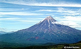
Kronotsky Volcano
|
||||||||||
| Location | ||||||||||
Volcano is location in the northern sector of the Eastern Kamchatkan volcanic area, 10 km east of Kronotsky Lake, 225 km northeast from Petropavlovsk-Kamchatsky.
|
||||||||||
| Form and structure | ||||||||||
Kronotsky is a stratovolcano with an ideal conical shape. There is a small andesibasalts extrusion at the summit. All historic eruptions and fumarolic activity were noted on a single fumarolic field situated on the southern slope at an altitude of 3,150 m. |
||||||||||
| Composition | ||||||||||
| Basalts and andesibasalts | ||||||||||
| Age | ||||||||||
| Upper Pleistocene | ||||||||||
| Links | ||||||||||
| Aviation color code |
GREEN |
| Last VONA/KVERT Releases |
No VONA/KVERT Releases |
| Hazard synopsis |
Summit eruptions are possible with ash plumes, ash falls, pyroclastic flows, lava flows, and lahars. The southern sector of the volcano is also an area of possible lateral eruptions. |
| Monitoring status |
satellite
|
| Eruptions |
|
1922 – 1923
|

