1000-20
54°45' N, 160°32' E, summit elevation 3521 m
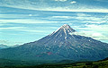
Fig.1
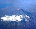
Fig.2
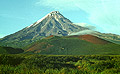
Fig.3
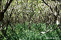
Fig.4
Perfectly shaped cone of Kronotsky (Fig.1) responds to
our general idea of a volcano and can well serve as an emblem of Kamchatka.
However, it is one of the least studied volcanoes and there is not much
to say about its Holocene activity.
The volcano was constructed mostly in Late Pleistocene and in terms of its morphology can be compared to such Late Pleistocene edifices as Opala and Koriaksky. The edifice is dissected by deep gullies (barrancos, Fig.2) and bears a summit glacier the northern lobes of which descend down the gullies as low as about 900 m ASL. The cone of the volcano is surrounded by moraines of the last phase of the Late Pleistocene glaciation (Fig.2), that means that it was one of the centers of the alpine glaciation at that time.
Weak eruptions were reported by local hunters in 1922 (black smoke on the southern slope) and 1923 (flames at the summit and low rumble), however our reconnaissance studies at the foot of the volcano have not allowed us to find any deposits of this age. Weak fumarolic activity was reported after the eruptions.
There are several cinder cones at the foot of the volcano (Fig.3). Two of them, located at the southwestern slope, formed 5-6 ka BP. The volcano's rocks are low-potassic basalt-basaltic andesite.
Our reconnaissance studies have allowed us to identify some tephra layers probably associated with Kronotsky eruptions. The most distinct of them lies immediately below KS1 regional marker ash (1800 years BP) and is presented by iron-stained brown coarse-grained ash. It can be well seen in the sections of the soil-pyroclastic cover at the southwestern foot of Kronotsky.
Lower slopes of the volcano are covered with dense bushes (Fig.4) that makes field work there rather complicated.
Literature