1000-083
52°42' N, 158°17' E, summit elevation 2173 m
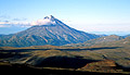
Fig.1
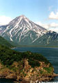
Fig.2
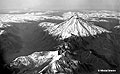
Fig.3
![]()
Fig.4
A schematic map of cinder cones north of Viliuchinsky volc.
Viliuchinsky volcano (Fig.1-3) is sitting on an uplifted plateau with an average altitude of 900-1000 m composed of Pliocene-Miocene rocks. The edifice of the volcano formed mostly in Late Pleistocene. In Early Holocene, about 10,000 years BP, the volcano produced a lava flow and moderate fall-out of basaltic andesite cinder. This event was likely the last serious eruption of the volcano. Later magma came to the surface through monogenetic vents located 7-14 km to the north (see a schematic map). The volcano's edifice was partially destroyed by landslides and rock avalanches, the deposits of which are exposed at the foot of the volcano. Landslides and rock avalanches pose a significant hazard to the adjacent localities and a major road along Paratunka river. Some of the landslides were caused by heavy rains as that of 1981, which came down the volcano slope after a cyclone named Elsa and killed several people on the road. Some of the debris flows could have been triggered by strong earthquakes.
Several cinder cones were formed on a plateau north of Viliuchinsky. Most of them like Mt. Barkhatnaya ("Velvet") are sitting just on the crests of eroded sub-volcanic bodies (Fig.4). Cinder cones were formed in two episodes; the first episode took place in Early Holocene, the later one 3-4 ka BP. The lava flows of these cones dammed the rivers and formed Zelenoe ("Green") and Topolovoe lakes.
Literature