57°35′ N, 160°38′ E, elevation 964.5 m
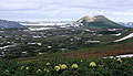
Fig. 1
An early Holocene (9–10 ka BP) Ozernovsky cinder cone (57°35′N, 160°38′E, elev. 964.5 m) and an associated ~100 km2 lava field are located on the eastern slope of the Sredinny Range in the upper streams of the Pravaia and Levaia Ozernaia rivers. Erupted products are medium-K basalt. The lava flow is known for its huge area and surface features typical for low-viscosity lavas. Unlike many other eruptions, which produced lavas of this type, however, Ozernovsky produced an extensive tephra fall dispersed mostly eastwards for more than 50 km. This tephra directly overlies glacial deposits. The lava flow filled glacial valleys and dammed a number of drainages to produce three large and few small lakes. GVP number 1000-59 is given to a neighbor Elovsky shield volcano and refers to Ozernovsky cinder cone as well (Siebert and Simkin, 2002-).
Literature
Braitseva OA, Melekestsev IV, Ponomareva VV, Sulerzhitsky LD (1995) The ages of calderas, large explosive craters and active volcanoes in the Kuril-Kamchatka region, Russia. Bull Volcanol 57 (6): 383-402
Ogorodov N. V., Kozhemyaka N. N., Vazheevskaya A. A., and A. Ogorodova (1972) Volcanoes and Quaternary Volcanism in the Sredinnyi Ridge of Kamchatka. Nauka, Moscow [in Russian]
Pevzner M.M. (2006) Holocene volcanism of Northern Kamchatka: The spatiotemporal aspect. Doklady of the Russian Academy of Sciences, Earth Sciences, Vol. 409A, No. 6, pp. 884–887. Original Russian text published in Doklady Akademii Nauk, 2006, Vol. 409, No. 5, pp. 648–651.
Siebert L, and Simkin T (2002-). Volcanoes of the World: an Illustrated Catalog of Holocene Volcanoes and their Eruptions. Smithsonian Institution, Global Volcanism Program, Digital Information Series, GVP-3, (http://www.volcano.si.edu/world/).