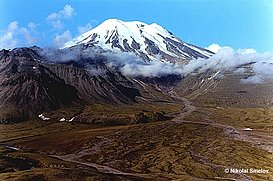
Ichinsky Volcano
|
||||||||||
| Location | ||||||||||
30 km to the west from the axial line of the Sredinny Ridge, 120 km northwest from Milkova settlement, 130 km east from Ichinsky settlement, 300 km northwest from Petropavlovsk-Kamchatsky.
|
||||||||||
| Form and structure | ||||||||||
It is one of the largest volcanic structures of Central Kamchatka – complex volcanic massif. |
||||||||||
| Composition | ||||||||||
| From basalts till rhyolites | ||||||||||
| Age | ||||||||||
| Middle Pleistocene | ||||||||||
| Links | ||||||||||
| Aviation color code |
GREEN |
| Last VONA/KVERT Releases |
No VONA/KVERT Releases |
| Hazard synopsis |
There are possibly explosive and explosive-effusive eruptions of the volcano a like as volcanoes if Iceland. It will be restricted to the caldera glacier with possible formation of meltwater within the caldera, which may trigger catastrophic floods down the valley of the Bystraya, Ketachan, Rassoshina, Anava, Belogolovaya River.
The volcano could constitute a potential hazard to international and low-flying aircraft. |
| Monitoring status |
satellite
|
| Eruptions |
|
1740
|

