Excursions
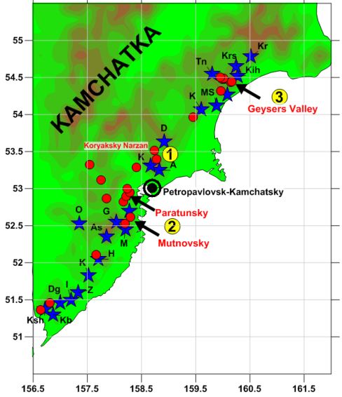
(1) Koryaksky Volcano’s Dyke Fields & Thermal Mineral Springs, (2) Mutnovsky &
Paratunsky Geothermal Areas, (3) Valley of Geysers.
Koryaksky Volcano’s Dyke Fields & Thermal Mineral Springs
The field trip lasts 10 hours (from 9-00 to 19-00). Number of participants is up to 10. Map
of the area and root points (Figure 1): IVS FEB RAS – Avachinsky Base /IVS Base (AVH)
– IVS FEB RAS (track-car); Avachinsky Base (AVH) – Dyke field on the south slope of Koryaksky
volcano – Koryaksky Narzan (К8) – Koryaksky Narzan (К2) – Koryaksky Narzan (К1) – Isotovsky
Hot Spring (IS) - Avachinsky Base (AVH) (helicopter). Foods: box lunch & Koryaksky Narzan
water (K1).
The trip costs 15 000 rubles per one participant. Prepayment on registration desk on Sept.
4 th 2018 in IVS FEBRAS. The number of participants is up to 10. The priority to participate
in the field trips is given to those who earlier submitted an extended abstract and PPT.
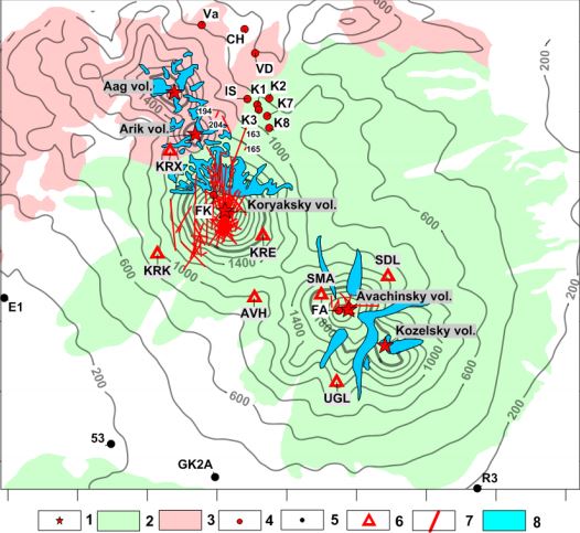
Figure 1 Geological map of the Koryaksky–Avachinsky volcanogenic basin. Legend: (1) The summits of
the Avachinsky, Koryaksky, Kozelsky, Arik, and Aag volcanoes; (2) Avachinsky, Koryaksky, Kozelsky
volcanoes and their eruptive products; (3) Pinachevsky extrusions Q2-3; (4) thermal features (for details,
see Table 1): FA - fumaroles on Avacha Volcano; FK - fumaroles on Koryaksky Volcano; K1, K2, K3, K7, K8
- thermal mineral springs of Koryaksky Narzan; IS - Izotovsky; VD - Vodopadny; CH - Chistinsky; Va -
Vakinsky; (5) deep hydrogeological wells; (6) KB GS RAS seismograph stations; (7) dykes traced at -3000
masl below Koryaksky Volcano and 1500 masl below Avachinsky Volcano; (8) glaciers. Note: The isolines
show the topographic surface, and the ticks along the axes represent intervals of 5 km.
The Avachinsky-Koryaksky volcanogenic basin (Figure 1), which has an area of 2530 km 2, is
located 25 km from Petropavlovsk-Kamchatsky City and includes five Quaternary volcanoes
(two of which, Avachinsky (2750 masl) and Koryaksky (3456 masl), are active), and is
located within a depression that has formed atop Cretaceous basement rocks. Magma injection
zones (dykes and chamber-like shapes) are defined by plane-oriented clusters of local
earthquakes that occur during volcanic activity (mostly in 2008-2011) below Koryaksky
and Avachinsky volcanoes at depths ranging from -4.0 to -2.0 km and +1.0 to +2.0 km,
respectively. Water isotopic (δD, δ18O) data indicate that these volcanoes act as recharge
areas for their adjacent thermal mineral springs (Koryaksky Narzans, Isotovsky and Pinachevsky)
and the wells of the Bystrinsky and Elizovo aquifers. Carbon δ13С data in СО2 from CO2
springs in the northern foothills of Koryaksky Volcano reflect the magmatic origin of
CO2. Carbon δ13С data in methane CH 4 reservoirs penetrated by wells in the Neogene-Quaternary
layer around Koryaksky and Avachinsky volcanoes indicate the thermobiogenic origin of
methane.
Mutnovsky and Paratunsky Geothermal Areas
The field trip lasts 10 hours (from 9-00 to 19-00). The number of participants is up to 10.
Map of the area and root points (Figures 2 & 3): IVS FEB RAS – V-Paratunsky hot springs
– IVS FEB RAS (track-car); V-Paratunsky hot springs – Vilyuchinsky Volcano – N-Zhirovskoy
hot spring (16) – Voynovsky hot spring (16) – V-Mutovsky GeoPP 12 MWe – Mutnovsky GeoPP
50 MWe – Dachny Steam Jets (7) – Dyke Field in Mutnovsky Volcano Crater (3) – Vulcannaya
River Waterfall 60 m – Cold Springs in Gorely Volcano - V-Paratunsky hot springs (helicopter).
Meals: box lunch & Silver Creek water (K1).
The trip costs 25 000 rubles per one participant. Prepayment on registration desk on Sept.
4 th 2018 in IVS FEBRAS. The number of participants is up to 10. The priority to participate
in the field trips is given to those who earlier submitted an extended abstract and PPT.
The Mutnovsky geothermal area is part of the Eastern Kamchatka active volcano belt. Mutnovsky,
80 kY old and an aging strato-volcano (a complex of 4 composite volcanic cones), acts
as a magma- and waterinjector into the 25-km-long North Mutnovsky extension zone (Figure
2). Magmatic injection events (dykes) are associated with plane-oriented MEQ (Micro Earth
Quakes) clusters, most of them occurring in the NE sector of the volcano (2 x 10 km 2)
at elevations from -4 to -2 km, while some magmatic injections occur at elevations from
-6.0 to -4.0 km below the Mutnovsky production field. Water recharge of production reservoirs
is from the Mutnovsky volcano crater glacier (+1500 to +1800 masl), which was confirmed
by water isotopic data (δD, δ18O) of production wells at an earlier stage of development.
The Mutnovsky (Dachny) 260-310°C high-temperature production geothermal reservoir with
a volume of 16 km 3 is at the junction of NNE- and NE-striking normal faults, which coincides
with the current dominant dyke injection orientation. TOUGH2-modeling estimates of the
reservoir properties are as follows: the reservoir permeability is 90-600 e-15 m 2, the
deep upflow recharge is 80 kg/s and the enthalpy is 1420 kJ/kg. Modeling was used to
reproduce the history of the Mutnovsky (Dachny) reservoir exploitation since 1983 with
an effective power of 48 MWe by 2016. Modeling also showed that the reservoir is capable
of yielding 65-83 MWe of sustainable production until 2055, if additional production
drilling in the SE part of the field is performed. Moreover, this power value may increase
to 87-105 MWe if binary technologies are applied. Modeling also shows that the predicted
power is sensitive to local meteoric water influx during development. Conceptual iTOUGH2-EOS1sc
5 thermal hydrodynamic modeling of the Mutnovsky magma-hydrothermal system as a whole
reasonably explains its evolution over the last 1500-5000 years in terms of heat recharge
(dyke injection from the Mutnovsky-4 funnel) and mass recharge (water injection through
the Mutnovsky-2 and Mutnovsky-3 funnels) conditions as previously mentioned.
The Paratunsky low temperature geothermal field (Figure 3) has been operating since 1964.
During the period of exploitation from 1966-2014, 321 Mt of thermal water (Cl-Na, Cl-SO4-Na
composition, M up to 2600 ppm) with temperatures of 70-100оС was extracted and used for
district heating, balneology and greenhouses. The structure of the 40 km 3 Paratunsky
low temperature (80-110°C) geothermal volcanogenic reservoir was geometrically characterized,
hot water upflow regions and the 3D permeability distribution were identified with hydrogeological
data, and the distribution of the feed zones and 3D temperatures were constrained by
3D spline approximation. Water isotope and gas (N 2, 96-98%) data analysis indicated
that the main recharge region of the Paratunsky geothermal reservoirs is the Viluychinsky
Volcano (2173 masl) and adjacent highly elevated structures, located 25 km south from
the geothermal field. Production zones coinciding with dip angle fractures occur in the
condition of radial extension (possibly caused by magmatic origin heat sources below
the reservoir) and hydraulic fracturing (possibly caused by the elevated position of
the Viluychinsky Volcano’s recharge region). TOUGH2 modeling of the thermo-hydrodynamic
natural state and the history of exploitation (involving pressure, temperature and chemical
changes response to utilization) between 1965 and 2014 yield estimates of hot water upflow
rates (190 kg/s), the production reservoir compressibility (up to 4×10⁻⁸ Pa- 1) and permeability
(up to 1.4 D). Modeling confirmed areal discharge of the thermal water from the production
reservoir in the top groundwater aquifer (top Dirichlet boundary condition s). Modeling
of the chemical (Cl-) history of exploitation provides an explanation of gradual Cl-
accumulation due to the inflow of chloride-containing water through the eastern (open)
boundary of the geothermal reservoirs. Modeling of the long-term exploitation until 2040
with an exploitation load of 256 kg/s merely shows a low pressure drop (0.7 bars) and
an insignificant drop of temperatures in the production geothermal reservoir of the Paratunsky
geothermal field.
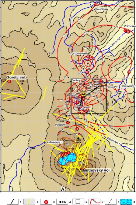
Figure 2. Schematic map and topography of the Mutnovsky geothermal area, grid scale 1 km.
Legend: 1 – Production 2D plane zone traces at -250 masl; 2 – Magmatic injection (dykes) 2009-2016
traces at -3000 masl; 3 – thermal features (1-18, see below); 4 – wells; 5 – rectangle is a detailed TH
model area; 6 – temperature isolines at -250 masl; 7 – AB – line of cross-section; and 8 – Glacier in the
Mutnovsky volcano crater. Note-1: M1, M2, M3, M4 – funnels of Mutnovsky volcanoes 1, 2, 3 and 4,
respectively (see section 2.3 for details). Note-2: MGeoPP – the existing Mutnovsky geothermal power
plant 50 MWe installed; VMGeoPP – the existing Verkhne-Mutnovsky geothermal power plant 12 MWe
installed; Dachny, Vulcanny, V-Zhirovskoy, Zhirovskoy-1, Zhirovskoy-2, and Vilyuchinsky – the potential
sites for additional geothermal electricity production.
Thermal features: 1 – Active funnel, 2- Bottom field, 3- Upper field, 4,5 – North-Mutnovsky East and
West, respectively, 6 – New 2003, 7 – Dachny (Active), 8 – Radon spring, 9 - Medveji, 10 – Gorely
volcano gas emission jets, 11 – Verkhne-Mutnovsky, 12 – Piratovsky spring, 13 – Voinovsky spring, 14,15
– Verkhne-Zhirovskoy chloride hot springs and fumaroles, respectively, 16,17 – Nizhne-Zhirovskoy
chloride hot springs, and 18,19 – Vilyuchinsky chloride hot springs and well R27, respectively.
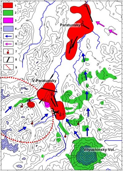
Figure 3 Paratunsky geothermal fields geo-filtration structure, recharge and boundary conditions,
topographical elevations in the background, grid scale 1 km.
Legend: 1 – counters of production geothermal reservoirs at -750 masl based on geoisotherm 75°C
(Paratunsky) and 60°C (Verkhne-Paratunsky); 2 – Holocene lava flows and cinder cones; 3 – Rhyolite
extrusions 0.5-0.8 MY; 4 – water recharge regions for the Paratunsky geothermal reservoirs (with an
elevation of more than 1000 masl); 5- Horizontal projections of fluid flows from recharge regions to the
production geothermal reservoirs; 6 – Chloride water attracted into the production reservoir due to its
exploitation; 7 – Hot springs; 8 – Production zone traces at -750 masl; 9 – Caldera rim 1.2-1.5 MY
(Leonov et al., 2007).
Valley of Geysers
The field trip lasts 10 hours (from 9-00 to 19-00). The number of participants is up to 5.
Map of the Valley of Geysers (Figure 4): IVS FEB RAS – Nikolaevka Airport – IVS FEB RAS
(car); Nikolaevka Airport – Valley of Geysers – Uzon Caldera – Nalychevsky Hot Springs
- Nikolaevka Airport (helicopter). Meals: box lunch & Malkinsky Water, swimming in the
Nalychevsky Hot Springs.
The trip costs 45 000 rubles per one participant. Prepayment on registration desk on Sept.
4th 2018 in IVS FEBRAS. The number of participants is up to 5. The priority to participate
in the field trips is given to those who earlier submitted an extended abstract and PPT.
The Geysers Valley hydrothermal system (Figure 4) is hosted within a system of two permeable
faults (revealed by mapping thermal features), located above a suggested partially melted
magmatic body and recharged by meteoric water along the outcrops of rhyolite-dacite extrusions.
Fast erosion is stimulating the significant discharge rate, the geyser´s cycling mode
and landslide events. Natural state thermal hydrodynamic modeling shows that 20,000-30,000
years of high temperature upflow of 250 kg/s and an enthalpy 900 kJ/kg can build up the
hydrothermal system in Geysers Valley basin with output discharge parameters comparable
to those at the current level. Modeling also shows that steam accumulation below an inclined
caprock may have hydrothermal eruption potential. The Giant landslide took place on June
3, 2007, when 20 x 106 m3 of rocks were shifted 2 km downstream, more than 23 geysers
were buried or submerged, and Podprudnoe Lake was dammed, injecting cold water into submerged
geysers. Possible triggers of the Giant Landslide include the inclination of the sliding
plane towards the Geysernaya river basin, a pressure increase in the fluid-magma system,
hanging block saturation by water during spring flooding, hydrothermal alteration weakening
of the sliding plane, and steam explosions.
The monitoring of the Velikan and Bolshoy geysers after the catastrophic landslide on 3.06.2007
(which dammed and created Podprudnoe Lake, drowning some geysers) and before a mudflow
on 3.01.2014 (which destroyed the dam and almost completely drained Podprudnoe Lake)
shows that the interval between eruptions (IBE) of the Bolshoy Geyser decreased from
108 to 63 min and that the IBE of the Velikan Geyser slowly declined over three years
from 379 min to 335 min. The seasonal hydrological cycle of the Velikan Geyser shows
an increase in the IBE during winter (average of 41 min). The dilution of the chloride
deep components of the Bolshoy (-17%) and Velikan Geysers (-12%) is also observed. A
local TOUGH2 model of the Velikan geyser is developed and is successfully calibrated
against temperature observations at both the mid-height and base of the conduit of the
Velikan Geyser, which shows the essential role of the CO2 in the functionality of the
geyser. A reservoir model of shallow production geysers is also developed. This 2D model
is used to describe changes in the thermal hydrodynamic state and evolving chloride concentrations
in the areas of most prominent discharge, both at steady state and when perturbed by
cold water injection from Podprudnoe Lake and other cold water sources (after 3.06.2007).
A “well on deliverability” option is used to model the geyser discharge features in the
model. The modeled increases in geyser discharge that is caused by an increase in the
reservoir pressure from cold water injection reasonably matches observations of IBE decreases
in the Bolshoy (~58%) and Velikan Geysers (~9%).
1941-2017 period of the Valley of Geysers monitoring (Kamchatka, Kronotsky Reserve) reveals
a very dynamic geyser behavior under natural state conditions: significant changes of
IBE (interval between eruptions) and power of eruptions, chloride and other chemical
components, and pre-eruption bottom temperature. Nevertheless, the total deep thermal
water discharge remains relatively stable, thus all of the changes are caused by redistribution
of the thermal discharge due to Giant Landslide of June 3, 2007, Mudflow of Jan. 3, 2014
and other events of geothermal caprock erosion and water injection into the geothermal
reservoir. In some cases, water chemistry and isotope data point to local meteoric water
9 influx into the geothermal reservoir and geysers conduits. TOUGHREACT V.3 modeling
of Velikan geyser chemical history confirms 20% dilution of deep recharge water and CO
2 components after 2014. Temperature logging in geysers Velikan (1994, 2007, 2015, 2016,
2017) and Bolshoy (2015, 2016, 2017) conduits shows pre-eruption temperatures below boiling
at corresponding hydrostatic pressure, that means partial pressure of CO2 creates gas-lift
upflow conditions in geyser conduits. Velikan geyser IBE history explained in terms of
gradual CO2 recharge decline (1941-2013), followed by CO2 recharge significant dilution
after the mudflow of Jan. 3, 2014 also reshaped geyser conduit and diminished its power.
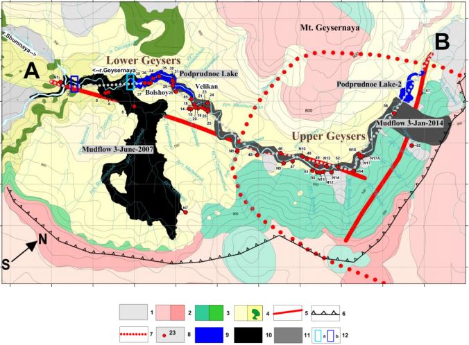
Figure 4 Schematic map of the Valley of Geysers. Legend: 1 - Alluvial and glacial deposits Q3-4; 2 -
permeable units of rhyolite, dacite and andesite extrusions (αξQ3
4
); 3 - basalt, andesite, and dacite lavas
and pyroclastics (αQ3
1-2
); 4 –low permeability units of caldera lake deposits (Q3
4
), which are complicated
by a dyke complex (Q3
3
ust); 5 – assumed thermal fluid-conducting faults; 6 – Uzon-Geysernaya caldera
boundary; 7 - uplifted area that is associated with the contours of the active magma reservoir (Lundgren
et al., 2006); 8 - geysers and hot springs (for numeration, see Table 6 in Kiryukhin, 2016); 9 - Podprudnoe
Lake and Podprudnoe Lake-2 dumb by mudflows; 10 - catastrophic landslide-mudflow on 3.06.2007; 11 -
landslide-mudflow on 3.01.2014; 12 – Geysernaya river flow rate measurement points: a – Podprudnoe
Lake exit, b – Geysernaya river mouth. Grid scale – 500 m. AB – grey dotted line of cross-section.
Volcanological Museum of the Institute of Volcanology & Seismology FEB RAS
One hour during September 5th 2018 (time TBD).
Additional Information
Contacts
For all questions concerning the organization of the meeting, contact
tvr62@mail.ru,
AVKiryukhin2@mail.ru
Follow the updates on the website of IVS FEB RAS:
http://www.kscnet.ru/ivs/.
Transport
Daily flights between Moscow and Petropavlovsk-Kamchatsky, frequent flights from, Khabarovsk and Vladivostok. Participants
from the US west coast can take a direct flight from Anchorage to Petropavlovsk-Kamchatsky.
For the participants from Japan and China, the connecting flights via Vladivostok is the
easiest way to get to the place of destination.
Accommodation
Hotels "Edelweiss", "Petropavlovsk", "Avacha" and "Oktyabrskaya". The most inexpensive rooms (about $ 100) are in the hotel
"Edelweiss", which is located near the Institute of Volcanology and Seismology FEB RAS.
Weather
The beginning of September in Petropavlovsk-Kamchatsky is usually sunny with a temperature of +16 оС, but the possibility
of a rain is not ruled out.
Cost
Workshop registration fee: 3000 rub. (includes the expenses for organization and conducting of the workshop and general events).
Circulars